Velebit by Train, Road, Mountain Pass an More
From the Lika Railway and the Gračac–Knin highlands to the Majstorska cesta, a journey through Croatia’s Dinaric landscapes reveals how differently infrastructure can experience the same mountains
Introduction
There is more than one way to cross or approach Velebit — and each route tells a different story.
The A1 motorway makes the journey fast, passing through the Sveti Rok tunnel and effectively hiding the mountain inside a massive piece of infrastructure. The Lika railway takes a much slower route through the high karst of inland Croatia, climbing towards Malovan before descending towards Knin. And the historic Majstorska cesta does something completely different again: it climbs directly over Velebit, winding through its bare limestone landscape at Mali Alan.
Together, these routes reveal an important distinction between travelling through a landscape and actually experiencing it. The train offers time and changing elevations; the motorway offers efficiency; the old mountain road offers direct contact with the terrain.
The result is not simply a journey across Croatia. It is a journey through the geological, historical and infrastructural character of the Dinaric Alps.
The train through Lika is a completely different experience from driving the A1. It is much more interesting if you want to see the landscape, rather than only pass through it.
Happy Climate Revolt Tuesday!
— Luka Jagor (@LukaJagor) October 6, 2026
🚆 By train – a completely different story
The Zagreb–Split train runs on the Lika railway, the Lička pruga, through Oštarije, Gospić, Gračac and Knin, and then on to Split. From Zagreb it shares the line toward Rijeka as far as Oštarije, then turns inland. It is the railway connection between continental Croatia and Dalmatia.
And most importantly: the train does not cross Velebit the way the A1 does. The motorway pierces the mountain in the Sveti Rok tunnel. The railway stays inland, through Lika and along the eastern side of the range, over plateaus and through numerous cuts, tunnels, bridges and bends.
So the feeling is something like:
Zagreb → Oštarije → forests → Lika → Gospić → karst → Gračac → Knin → descent towards Dalmatia → Split
From Gračac towards Knin, the line climbs to Malovan station, crosses the upper Zrmanja country, and then descends towards Knin. Malovan station stands at 793 m. This is the railway summit, a different place from the Velebit peak also called Malovan, which rises to about 1,709 m near Sveto Brdo.
But that's the point! 🤩
When the train goes Gračac → Knin, it enters this dramatic mountainous area. The line passes along the eastern slopes of southern Velebit, through the upper Zrmanja country, then takes a long winding descent towards Knin. The famous Zrmanja canyon, the one near Obrovac, lies much farther downstream. The train does not run through that canyon.
The Lika line was deliberately laid out as a long, winding route. In places the curves tighten to a radius of 250 m, and the steepest gradient is 25‰. The highest point of the whole line is 876 m near Rudopolje, north of Gospić. Rudopolje station itself is at 870 m. The Gračac–Knin section has its own, lower summit, at Malovan.
🚆 The highest point of this crossing is at Malovan
The top of the climb is Malovan station, at 793 m. Cerovac, at 674 m, is still on the way up. HŽ Infrastruktura lists Gračac, Cerovac, Malovan, Zrmanja and the other stops, with the kilometre position of each one.
Read as a straight line, the heights go like this:
Gračac 555 m → Cerovac 674 m → ⛰️ Malovan 793 m → Zrmanja 637 m → Pribudić 605 m → Plavno 490 m → Pađene 380 m → Knin 221 m.
The train also passes Prljevo, between Pribudić and Plavno, and Oton and Stara Straža, between Plavno and Knin. The list above is the shape of the climb and the descent.
So “climbing to Malovan and then descending towards Knin” is literal. 😄
Figuratively:
- Korlat / Posedarje → 🏔️ Velebit looks like a huge wall
- Gračac → 🚗 you are already high in the Lika karst
- Malovan → 🚆 the railway reaches 793 m
- Knin → 🌄 a long descent towards Dalmatia

Novigrad Sea And Velebit
A wide panoramic view of the approach to Posedarje, with the town sitting beneath the dramatic slopes of Velebit and the Novigrad Sea appearing at the edge of the frame.
View the photograph →🚆 On the Gračac–Knin section, the Lika railway climbs from 555 m at Gračac to 793 m at Malovan, then descends to 221 m at Knin.
That is why the train is more interesting for the feeling of height. It does not reach an extreme altitude. It stays with mountainous country for a very long time.
On the train Zagreb → Gračac → Knin, the mountain section runs:
Gračac → Cerovac → Malovan → Zrmanja → Pribudić → Prljevo → Plavno → Pađene → Knin
After Knin, the railway leaves Velebit behind. It turns southwest, through the Dalmatian hinterland, towards Drniš and Split.
Knin is a railway crossroads. The lines to Gračac and Zagreb, to Zadar, and to Split meet here, and so does the Una line towards Novi Grad. After Knin, the train to Split goes through Kosovo, Drniš, Perković and Kaštela to Split.
Knin sits among mountains. The Knin Tourist Board names nine: Orlovica, Vilica, Plješevica, Bukovac, Badnja, Dinara, Kozjak, Svilaja and Promina. Dinara is one of them. Velebit is not. Velebit stands well to the northwest. The Kozjak on this list is inland Veliki Kozjak, also called Kijevski Kozjak, above Kijevo. The Kozjak above Kaštela, which the train passes later, is a different and lower coastal ridge.

Knin → Drniš → Split
🏔️ Dinara / Promina / Svilaja become the dominant mountains
The Zagreb–Split train therefore gives you two completely different mountain landscapes: first Lika and the eastern side of Velebit, then, after Knin, the Dalmatian mountain country around Dinara, Promina and Svilaja. The rock is closely related. What you see on the ground can look quite different. Velebit is part of the Dinarides.
🪨 What is the same?
Both Velebit and Dinara belong to the Dinaric Alps and are largely made of Mesozoic limestones and dolomites. That means:
hard carbonate rock
lots of cracks and faults
highly developed karst
sinkholes, pits and caves
surface water that often disappears underground
Geologically, Velebit and Dinara belong to the same large Dinaric karst system.
🏔️ But why do they look so different?
Velebit is a long ridge along the Adriatic. It is strongly faulted and folded, with a steep face towards the sea. From Posedarje and Korlat, across the flatter Zadar hinterland, that face can look like one continuous stone wall.
Velebit also has its own breccias, the Jelar beds: carbonate rock broken into fragments and cemented again. They are Paleogene, younger than the main Mesozoic limestone, and they weather readily.
Dinara is karst of a different shape. It has large karst plateaus, fields, sinkholes and high pastures, and its summits stand higher than Velebit’s. Sinjal on Dinara is 1,831 m. Vaganski vrh on Velebit is 1,757 m. Dinara Nature Park is built mainly of Jurassic and Cretaceous limestone, with very pronounced karst.
Visually, from the train 🚆
Along this route the view changes:
Gračac / Malovan
→ open high karst: stone, grassy plateaus, wide space
towards Knin
→ deeper cuts, karst valleys and a sharper mountain relief. This is the upper Zrmanja country, not the canyon near Obrovac.
Knin → Drniš → Split
→ another face of the Dinaric Alps: Dinara, Promina, Svilaja and Kozjak, a country of separate mountain masses.
A photograph taken near Posedarje shows the same trick of perspective. Distance, the shape of Velebit, and the flat Zadar hinterland in front of it turn the mountain into an apparent wall.
The Via Dinarica descriptions say the same thing about the corridor: the D1 from Gračac to Knin and the Zagreb–Split railway run side by side through very sparsely populated country. The road distance is about 55 kilometres. The railway winds, so the train covers about 64 kilometres between Gračac and Knin.
📸 Good places to take photos
Malovan – Otrić
The strongest candidate for a dramatic view from the road, and the stretch for a photograph of Poštak.Gračac – the Crnopac area
Wide, open karst. Crnopac has a striking rock texture.Otrić – Zrmanja
Wilder country, with fewer settlements and less infrastructure. Zrmanja station is the usual start of the walk up Poštak.Gračac towards Malovan
Views back over the high mountains and open Lika.
A small note: do not stop at every lay-by on the D1. Some are fine for a short pause. Watch the traffic, and stop only where you can pull off safely.
Historic road in Croatia
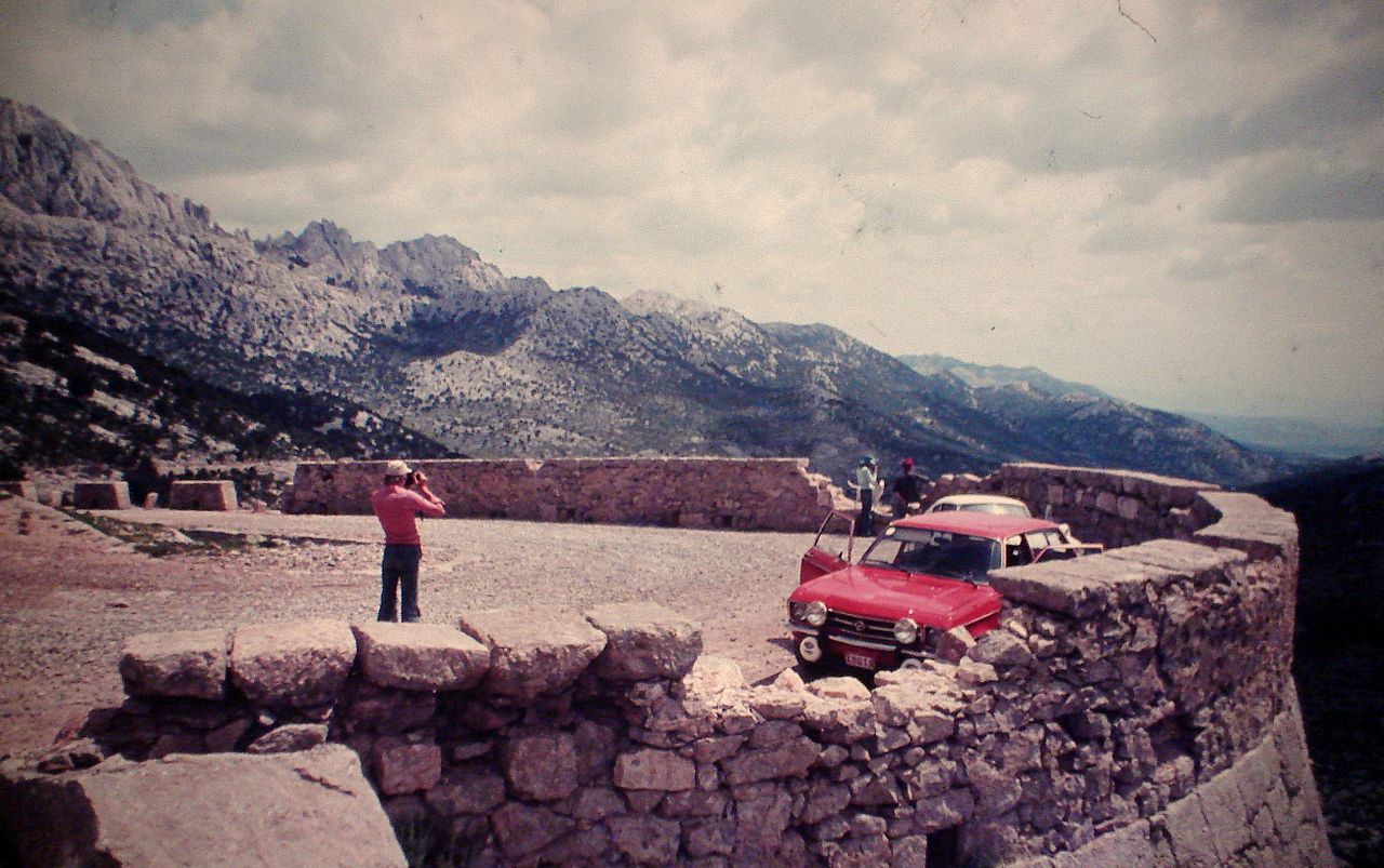
Tulove grede
A view of the distinctive Tulove grede formations on Velebit.

Mali Alan – Sveti Rok
Underpinned gravel section of the historic road between Mali Alan and Sveti Rok.

Majstorska cesta
A view of the historic Majstorska cesta near Jasenice, Croatia.
The Majstorska cesta, the masterpiece road, was built to shorten the journey from Lika to Dalmatia by crossing Velebit. Today it is a different kind of road entirely.
Why was it built?
The road runs Sveti Rok → Mali Alan → Obrovac. Today it is state road D547. Josip Kajetan Knežić built it from 1825 to 1832 to shorten the link between Lika and Dalmatia, and it opened on 4 October 1832. The historic road is 41 km long. The modern D547 measures 38.15 km. It crosses Velebit at the Mali Alan pass, 1,045 m.
Majstor is a master craftsman, and the Croatian name is traced to the German Meisterstück, a masterpiece, because of the way the road was made.
From Lika towards Zadar there are two routes:
1. Today’s main route
Sveti Rok → A1 → Sveti Rok tunnel → Posedarje / Zadar
2. Majstorska cesta
Sveti Rok → 🏔️ Mali Alan → Tulove Grede → Podprag → Obrovac
The second is much slower. It takes you over Velebit, not through it. 😄
And why do people still drive it?
Because the landscape is extraordinary. The road is cut along the steep slope of Velebit, through switchback after switchback, between gorges and rocky ridges, and right beside Tulove Grede. The mountainside is steep. The road itself was kept to a maximum gradient of 5.5%. Much of the mountain section is still macadam, and the bura at Prag can be severe.
That brings us back to the earlier photograph.
At Korlat you see Velebit from a distance, across the Zadar hinterland:
🌾 Korlat → 🏔️🏔️🏔️ Velebit
On the Majstorska cesta you are inside the mountain:
🚗 → serpentine → 🪨 rock → 🌲 → 🏔️ → serpentine → Dalmatia
That is why photographs from this road look so dramatic.
One important thing about driving it
It will not get you to Dalmatia faster than the A1. It is a historic mountain road. Its value now is the landscape and the old route. It was once the trade and post road between Vienna and Zadar. It is now a protected scenic road.
The Republic of Croatia has protected it as a cultural asset since the end of 2007. That protection also stopped a plan to asphalt it.
If the aim is to cross Velebit by car and see that bare, dramatic karst, the Majstorska cesta is a much more direct experience of the mountain than the D1 from Gračac to Knin.
D1 = the Lika and Dinaric corridor.
Majstorska cesta = a climb directly over Velebit.
Energy note · Knin Fortress
Knin Fortress and Renewable Energy: What We Can Actually Say
Knin Fortress is part of a region with substantial renewable-energy generation. That makes its nighttime lighting an interesting energy question — but it does not mean the fortress is directly powered by the nearby wind or solar plants.


Knin is surrounded by an electricity system with significant renewable-energy generation, including wind and solar power.
That electricity generated by a particular nearby renewable power plant is physically dedicated to the fortress lighting.
So, does renewable energy cover the lighting?
At the regional system level, renewable generation can be vastly larger than the electricity required for the fortress lighting. But without metering data, a dedicated supply arrangement, or documentation identifying the source of the electricity, we cannot claim that the nighttime illumination is directly powered by those nearby renewable plants.
Croatian Civil Engineering
From crisis to concrete: A1 and the Adriatic–Ionian corridor—progress you can drive on. The railways reflect a slower path of change.
⚡ Knin and the Modern Energy Landscape
The story does not end with transport.
Knin has also become part of an important renewable-energy region. The surrounding electricity system includes significant wind and solar generation, although this should not be confused with electricity from a particular renewable plant being physically dedicated to individual buildings.
That distinction matters especially when discussing the nighttime illumination of Knin Fortress. Regional renewable generation can contribute electricity to the public grid, but without dedicated supply arrangements, metering data or other documentation, it cannot be claimed that a particular nearby wind or solar plant directly powers the fortress lighting.
The wider Knin area nevertheless illustrates how dramatically the infrastructure landscape has changed. Nearby wind generation includes the Ljubač wind farm, while the wider region also contains the Krš-Pađene wind project. Solar capacity is expanding as well.
The mountains that once represented an obstacle to transport are now also becoming a landscape for renewable-energy infrastructure.
Conclusion
Travelling across northern and central Dalmatia is therefore about much more than getting from Zagreb to Split.
The A1 makes Velebit disappear into a tunnel. The Lika railway lets the traveller spend time inside the high karst, climbing to Malovan before descending towards Knin. The Majstorska cesta takes the most intimate route of all, climbing directly across Velebit through Mali Alan and Tulove Grede.
These routes show how infrastructure changes our perception of geography.
A mountain can be an obstacle to tunnel through, a gradient to climb, a landscape to photograph, or a historic route to preserve. The same Velebit can therefore appear as a distant stone wall from Korlat, a long sequence of railway curves near Malovan, or an immense rocky landscape from the old road above Sveti Rok.
And that may be the most interesting lesson of the journey: the way we move through a landscape determines how much of that landscape we actually see.
References
HŽ Infrastruktura — railway infrastructure and station information for the Lika railway, including Gračac, Cerovac, Malovan, Zrmanja, Pribudić, Plavno and Knin.
Via Dinarica — information on the D1 corridor between Gračac and Knin and the relationship between the road and railway corridors.
Croatian road and cultural-heritage sources — historical information on the Majstorska cesta, D547, Mali Alan and its protected cultural status.
Knin Tourist Board — information on the mountains surrounding Knin.
Renewable-energy project information — regional wind and solar generation around Knin, including Ljubač and Krš-Pađene.
Wikimedia Commons — historical and contemporary Velebit photographs used in the accompanying gallery, including Tulove Grede, Mali Alan–Sveti Rok and Majstorska cesta.
Luka Jagor, Nature+ Photography — Novigrad Sea and Velebit, documenting the visual relationship between Posedarje, the Novigrad Sea and Velebit.


Comments
Post a Comment